
↓
 

Jacksonville Land Surveying

Information related to Land Surveying Services in Jacksonville, Florida

Jacksonville Land Surveying
  • Home
  • ALTA Survey
  • Boundary Surveying
  • Construction Survey
  • Drone LiDAR Mapping
  • Elevation Certificate
  • Land Surveying
  • Topographic Survey
  • Blog
  • Contact Us
Home - Page 7 << 1 2 … 5 6 7 8 9 … 15 16 >>

Post navigation

← Older posts
Newer posts →

What Is an As-Built Survey and Why Is It Required After Construction?

Jacksonville Land Surveying Posted on June 2, 2026 by JaxsurveyorJune 9, 2026
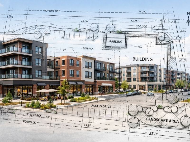
Completed commercial development with an as-built survey overlay showing building locations, parking areas, setbacks, and site improvements

The building is done. The crew packs up. You call for a final inspection, and the building department tells you they need an as-built survey before they can issue a Certificate of Occupancy. If you didn’t plan for it, that request stops your project cold. An as-built survey is the final documentation step in most construction projects, and skipping it or scheduling it too late creates real delays. Here’s what it is, what it covers, and when you actually need one.

What an As-Built Survey Is

An as-built survey is a field survey done after construction is complete. A licensed land surveyor visits the site and measures the actual location, dimensions, and elevations of everything that was built. That data gets compared to the approved site plan and permit drawings.

The goal is simple: confirm that what was built matches what was approved.

Plans change during construction. Contractors shift a building a few feet to avoid a utility line. Grading gets adjusted for drainage. A driveway ends up in a slightly different spot. All of those changes need to be documented. The as-built survey captures the finished reality of the site, not the design intent.

Only a licensed Professional Surveyor and Mapper (PSM) under Chapter 472 of the Florida Statutes can prepare and certify an as-built survey. It’s not something a contractor, architect, or engineer can complete on their own.

What an As-Built Survey Documents

The specific content depends on the project, but most as-built surveys for new construction document:

  • Building footprint location and distance to all property lines (setback verification)
  • Finished floor elevation, especially critical on properties in or near FEMA flood zones
  • Driveway, parking area, and impervious surface coverage
  • Pool, fence, retaining wall, and accessory structure locations
  • Grading, drainage swales, and retention features as constructed
  • Utility service connections (water, sewer, electric) where visible or documented by the contractor
  • Any deviations from the approved site plan

The surveyor checks each of these against the permit drawings and zoning requirements. If the building sits within setback tolerances and the finished floor elevation meets flood zone requirements, the survey supports the CO application. If there’s a problem, it gets flagged before occupancy is approved.

Why Municipalities Require It

Building departments require as-built surveys because inspections alone can’t verify exact measurements. An inspector can confirm that framing passes code. They can’t confirm that the structure sits exactly 7.5 feet from the side property line without a survey-grade measurement.

The as-built survey closes that gap. It gives the local building authority a certified, field-verified document showing that the finished structure complies with the approved plans, setback requirements, and any flood zone elevation rules that applied to the permit.

Most jurisdictions require an as-built survey as part of the Certificate of Occupancy package for new residential and commercial construction. Some also require it for substantial improvements to existing structures, generally defined as repairs or renovations where the cost equals or exceeds 50% of the structure’s pre-improvement market value.

For construction loans, the lender often requires the as-built survey at project closeout before releasing the final draw or converting to permanent financing. This protects the lender by confirming the collateral (the finished building) was actually built as planned.

When to Schedule It

Timing matters. The surveyor needs the site to be substantially complete before fieldwork begins. That means:

  • The structure is finished and all exterior work is done
  • Final grading is in place
  • Driveways, walkways, and any other permanent site improvements are complete
  • Utility connections are made and accessible

Scheduling the survey too early wastes money because the surveyor has to return. Most residential sites take two to four hours of fieldwork. Office processing follows. A typical residential as-built survey is delivered within five to ten business days from the field visit, though timelines vary by firm and project volume.

Plan for the survey at least two weeks before you need the CO. If the survey reveals a setback issue or a finished floor elevation that doesn’t meet requirements, you need time to resolve it before the inspection.

As-Built Survey vs. Building Inspection

These two things serve different purposes and are often both required.

A building inspection is conducted by the local building department. An inspector checks that the construction meets applicable building codes, electrical standards, plumbing requirements, and structural specifications.

An as-built survey is conducted by a licensed surveyor. It measures and certifies the physical location and elevation of the completed improvements relative to property lines, setbacks, and approved plans.

One checks code compliance. The other checks spatial accuracy. Both may be required before a Certificate of Occupancy is issued.

What It Costs

As-built survey costs range from about $500 to $2,500 or more depending on the project scope. A straightforward single-family home with a simple footprint and no flood zone requirements sits at the lower end. A larger commercial building with multiple structures, extensive site improvements, and flood zone elevation documentation sits higher.

Compared to the cost of a delayed closing or a zoning violation discovered after occupancy, the survey cost is small. Construction surveys across all phases typically run 1 to 3 percent of the total construction budget, and they prevent mistakes that can cost 10 to 50 times more to fix.

Frequently Asked Questions

What is an as-built survey? 

An as-built survey is a field survey performed by a licensed land surveyor after construction is complete. It documents the actual location, dimensions, and elevations of all improvements as they were built, and compares that data to the approved site plan to verify compliance with setbacks, flood zone requirements, and permit drawings.

Is an as-built survey required for a Certificate of Occupancy? 

Most building departments require an as-built survey as part of the CO package for new construction. The survey confirms that the finished structure meets required setbacks, finished floor elevations, and any flood zone compliance conditions tied to the building permit.

Who can prepare an as-built survey? 

Only a licensed Professional Surveyor and Mapper (PSM) licensed under Chapter 472 of the Florida Statutes can prepare and certify an as-built survey. Contractors, architects, and engineers cannot certify this document.

When should I schedule an as-built survey? 

Schedule the survey after construction is substantially complete, including final grading and all permanent site improvements. Plan for it at least two weeks before you need the Certificate of Occupancy to allow time for fieldwork, office processing, and any corrections if issues are found.

What happens if the as-built survey shows a problem? 

If the survey reveals a setback violation, an elevation that doesn’t meet flood zone requirements, or an encroachment onto an easement, the building department will not issue the CO until the issue is resolved. Depending on the severity, the fix may require modifying the site, obtaining a variance, or amending the permit.
Posted in land surveying | Tagged as-built survey, construction survey, construction surveyor

What Does an ALTA Land Survey Cover That Other Surveys Don’t?

Jacksonville Land Surveying Posted on June 1, 2026 by JaxsurveyorJune 9, 2026
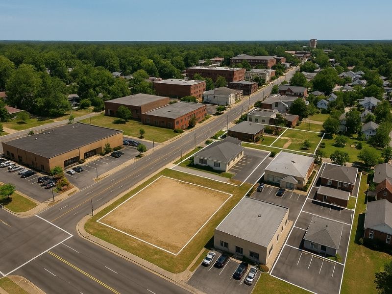
Aerial view of a commercial property showing building locations, parking areas, and site features documented in an ALTA Land Survey

You’re under contract on a commercial property. Your lender orders a survey. The title company sends back a long list of requirements. At the top: an ALTA land survey. If you’ve only dealt with residential boundary surveys before, the scope of an ALTA can feel like a surprise. It covers a lot more ground, and for good reason. The stakes on a commercial deal are too high for a basic property line map.

What Makes an ALTA Land Survey Different

A standard boundary survey does one core job: it locates and maps property lines. That’s useful for residential closings, fence placements, and simple ownership questions. But it stops there.

An ALTA land survey (formally called an ALTA/NSPS Land Title Survey) goes much further. It follows a joint national standard set by the American Land Title Association and the National Society of Professional Surveyors. That standard exists specifically to give lenders, title insurers, and buyers a consistent, detailed picture of a property regardless of which state the transaction happens in.

Where a boundary survey confirms where your land ends, an ALTA survey documents what’s on it, what runs through it, who has legal rights to parts of it, and whether anything about it conflicts with local rules or recorded documents.

What the Base ALTA Survey Always Includes

Before any optional items are added, every ALTA survey covers several things a standard boundary survey does not.

Improvements are fully located and mapped. This means buildings, paving, parking areas, fences, retaining walls, and signage are all shown with their exact positions relative to the property lines. If a neighbor’s fence crosses your boundary by three feet, that shows up. If your parking lot extends into a utility easement, that shows up too.

Easements visible in the field get documented. That includes utility corridors, access paths, and drainage easements. Some of these appear in title records. Others are unrecorded but physically present. The ALTA survey captures both.

Access to the property is verified. The surveyor confirms how the parcel connects to public roads. If access depends on an easement across another owner’s land, that gets noted. A buyer finding out after closing that their property has no legal access to a public street is a serious and preventable problem.

Above-ground evidence of utilities is located as part of the base standard. Water meters, sewer manholes, utility poles, overhead lines, gas valves, and fire hydrants near or on the property are all shown.

What Table A Adds on Top

The ALTA standard also includes a list of optional items called Table A. These are agreed upon in writing before the surveyor starts fieldwork. Lenders and title companies typically require specific Table A items depending on the property type and transaction.

The 2026 ALTA/NSPS standards include 20 Table A items. Some of the most commonly required ones:

  • Flood zone classification and Base Flood Elevation data
  • Zoning setbacks, height restrictions, and buildable envelope mapped on the plat (based on a separately ordered zoning report)
  • Underground utility locations (an addition to the above-ground evidence already in the base standard)
  • Parking space count and dimensions
  • Building square footage and exterior dimensions
  • Wetland delineation for properties near water or environmentally sensitive areas

The 2026 standards added Item 20, which requires the surveyor to include a structured five-category encroachment summary directly on the plat face. This replaces the older catch-all disclaimer and gives lenders a clearer record of any encroachment issues before closing.

Adding the full standard Table A package to a base ALTA survey typically adds $500 to $2,000 to the cost, depending on which items are selected and the complexity of the site.

Why Lenders and Title Companies Require It

Title insurance policies carry a standard “survey exception” that excludes coverage for anything a current survey would reveal. When an ALTA survey is provided, the title insurer can remove that exception from the policy.

That’s a significant benefit for buyers and lenders. It means the policy actually covers encroachments, access issues, and boundary problems that a basic survey would have caught but wasn’t ordered to show.

Commercial lenders require ALTA surveys because they need that exception removed before they’ll fund. The loan depends on clean title, and clean title requires the kind of detail only an ALTA produces.

What an ALTA Survey Costs

Commercial ALTA surveys typically range from $2,500 to $10,000 or more, depending on the size and complexity of the property. A straightforward urban parcel with a single building costs less than a multi-acre mixed-use site with multiple easements, structures, and active utilities.

That’s a meaningful cost. But consider what’s at risk. A missed encroachment, an unrecorded easement, or a zoning setback violation discovered after closing can result in losses that far exceed the cost of the survey.

When You Actually Need an ALTA vs. a Boundary Survey

A boundary survey is the right tool for residential properties, fence placements, and basic ownership disputes. It’s faster and less expensive.

An ALTA land survey is the right tool when:

  • You’re buying or financing commercial real estate
  • Your lender or title company specifically requires one
  • The property has multiple buildings, easements, or complex access
  • You need title insurance with the survey exception removed
  • The transaction involves investors, lenders, or parties located outside the state where the property sits

For large multifamily residential developments, ALTA surveys are also standard. A 200-unit apartment project carries the same legal complexity as a commercial deal.

Frequently Asked Questions

What is an ALTA land survey? 

An ALTA land survey is a property survey that follows national standards set jointly by the American Land Title Association and the National Society of Professional Surveyors. It maps property boundaries, improvements, easements, utilities, and other physical and legal details required for commercial real estate transactions and title insurance.

What does an ALTA survey show that a boundary survey doesn’t? 

A boundary survey maps property lines. An ALTA survey goes further by documenting the location of all improvements, easements (both recorded and visible), utilities, access rights, flood zone data, and optional details like zoning setbacks, building dimensions, and underground utilities. It also allows the title insurer to remove the standard survey exception from the title policy.

Who orders an ALTA survey? 

The lender or title company typically specifies that an ALTA survey is required, but either the buyer or seller may be the one to hire the surveyor depending on the terms of the transaction. The Table A items required are usually dictated by the lender.

How long does an ALTA survey take? 

Most ALTA surveys take two to four weeks from the date of engagement, depending on the size of the property, the number of Table A items selected, and how quickly the surveyor receives the title commitment and any prior survey documents.

What are ALTA Table A items? 

Table A is a list of optional additions to the base ALTA survey. The 2026 standards include 20 items covering things like flood zone classification, underground utilities, zoning setbacks, wetlands, building dimensions, and parking counts. Lenders and title companies specify which items they require for each transaction, and each item adds to the total survey cost.

Posted in alta survey | Tagged alta land survey, Land Surveying, land surveyor

Wrong Flood Zone? Get a LiDAR Survey

Jacksonville Land Surveying Posted on May 22, 2026 by JaxsurveyorMay 13, 2026
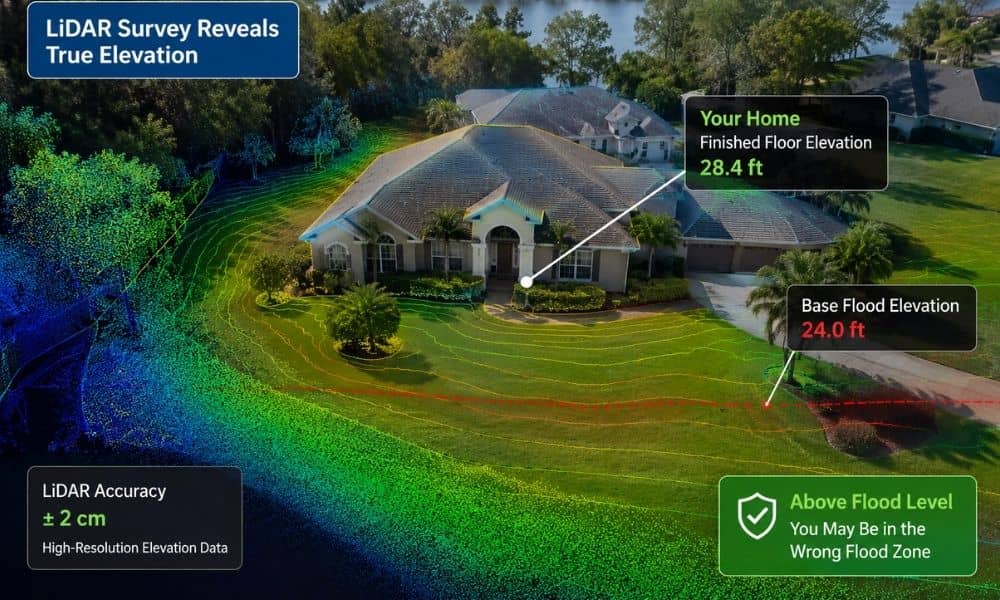
Aerial view of a residential property with LiDAR elevation mapping used to verify flood zone accuracy

If your home is labeled high-risk on a FEMA flood map, a LiDAR survey can tell you whether that label is actually correct. A LiDAR survey is a laser-based land measurement tool that captures precise elevation data across your entire property. If the results show your land sits above the flood level, you have the evidence needed to challenge your flood zone status and remove your flood insurance requirement for good.

Many homeowners pay for flood insurance they do not need. This happens because FEMA’s flood maps were built with old, inaccurate data. A LiDAR survey gives you precise measurements that those old maps never had.

Why Flood Zone Maps Are Often Wrong

Jacksonville has real flood risks. The St. Johns River, tidal creeks, and heavy rain all cause flooding in many areas. But not every property labeled high-risk on a FEMA map actually is.

FEMA flood maps were built using old tools. Those tools measured terrain in 20-foot intervals. In a flat city like Jacksonville, even one foot of elevation can change your flood risk. Old tools simply could not catch that.

LiDAR surveys measure elevation down to a few centimeters. A property that looks like it is inside a flood zone on an old map might actually sit well above the danger level when measured with LiDAR.

Many homeowners have been paying $1,000 to $3,000 a year in flood insurance. Some of them are paying based on bad data. A LiDAR survey can find out the truth.

What a LiDAR Survey Measures on Your Property

A LiDAR survey captures millions of data points across your land. It also covers the terrain around your property. This level of detail is far beyond what older survey tools could produce.

The data is turned into what is called a bare earth model. This shows the true shape of your land at ground level. Trees, buildings, and vegetation are removed from the picture. What is left is an exact map of the soil beneath your feet.

From that model, your surveyor finds two key numbers. The first is the elevation of the lowest ground point touching your home. The second is the elevation of your finished floor. Both numbers are compared to the flood level set by FEMA for your area.

If your LiDAR survey shows your land is at or above that flood level, you are likely in the wrong flood zone.

Can a LiDAR Survey Get Me Out of a Flood Zone?

Once a LiDAR survey shows your property sits above the flood level, your surveyor uses that data to prepare an elevation certificate. This is the official document that records your property’s elevation. FEMA requires it before reviewing any flood zone challenge.

With the elevation certificate ready, you can apply for a Letter of Map Amendment, called a LOMA. This is FEMA’s process for fixing a wrong flood zone label. If FEMA approves it, your property is removed from the high-risk zone. Your lender can then drop the flood insurance requirement. You may also get a refund on premiums you already paid.

The LiDAR survey is what starts all of this. Without it, none of the steps above are possible.

Why LiDAR Surveys Are More Reliable Than Older Methods

Before LiDAR, surveyors used manual tools and older GPS equipment. These worked well enough for small areas. But they could not capture the full picture of a property and its surrounding land.

A LiDAR survey covers your entire property in one pass. It does not rely on a few spot measurements. It captures every inch, including small slopes and low areas that older tools would miss.

For properties near water or wetlands, this matters a lot. A six-inch difference in elevation can change your flood zone status. A LiDAR survey finds those six inches. An older survey might not.

Is a LiDAR Survey Worth It?

If you are paying mandatory flood insurance and your home has never flooded, the answer is most likely yes.

A residential LiDAR survey typically costs a few hundred dollars to around $700. That is a one-time fee. If it leads to a successful flood zone challenge, the savings start right away. A $2,000 annual insurance premium removed means the survey pays for itself in just a few months.

Even if the survey confirms you are correctly placed in a flood zone, you now have accurate data about your land. That is useful for building, drainage planning, and when you decide to sell.

Frequently Asked Questions

What does a LiDAR survey show that older surveys do not? 

A LiDAR survey captures millions of elevation points across your full property. Older surveys only measure a few spots. In flat areas like Jacksonville, that difference can reveal flood zone errors that older tools completely miss.

Can a LiDAR survey get me out of a FEMA flood zone? 

Yes, if the results show your property sits at or above the Base Flood Elevation. Your surveyor uses the LiDAR data to prepare a certified elevation certificate. That certificate is submitted to FEMA as part of a formal flood zone challenge.

How accurate is a LiDAR survey for flood zone purposes?

 LiDAR measures elevation down to a few centimeters. FEMA’s older flood maps used data accurate only to 20-foot intervals. That gap in precision is why a LiDAR survey can find flood zone errors that old maps cannot.

How long does a LiDAR survey take for a home?

 Data collection takes a few hours. Your surveyor can deliver the final results and certified elevation certificate within 3 to 7 business days.

Do I need a licensed surveyor to use LiDAR data for a flood zone challenge?

 Yes. Only a licensed Professional Surveyor and Mapper can certify the data. Without that certification, FEMA will not accept the results.

Posted in land surveying | Tagged lidar mapping

Post navigation

← Older posts
Newer posts →
Get Quote Button

Jacksonville Florida Land Surveyors

© Copyright Jacksonville Land Surveying
Jacksonville, FL
Phone: 904-712-2289

Privacy Policy | Terms of Use
Web Development and SEO by:
N2Biz.co
↑