
↓
 

Jacksonville Land Surveying

Information related to Land Surveying Services in Jacksonville, Florida

Jacksonville Land Surveying
  • Home
  • ALTA Survey
  • Boundary Surveying
  • Construction Survey
  • Drone LiDAR Mapping
  • Elevation Certificate
  • Land Surveying
  • Topographic Survey
  • Blog
  • Contact Us
Home - Page 6 << 1 2 … 4 5 6 7 8 … 15 16 >>

Post navigation

← Older posts
Newer posts →

How Survey Mapping Reveals Easements and Drainage Issues

Jacksonville Land Surveying Posted on June 9, 2026 by JaxsurveyorJune 8, 2026
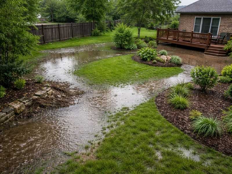
Survey mapping showing standing water and drainage issues affecting a residential property

Building a commercial property on an unmapped piece of land can lead to disaster. You might clear the ground, pour the concrete and start framing your building. Then a city worker shows up with a shutdown order because your new structure sits right on top of a major drainage pipe. Investing in professional survey mapping protects your investment from these unexpected stoppages by identifying hidden risks before construction crews arrive.

A clear land map tells your design team exactly where they can build and where they must leave the ground untouched.

Locating Hidden Land Agreements

An easement is a legal right that allows someone else to use a portion of your land. Some easements are easy to spot, like a wide gravel driveway crossing a lot. Others remain completely invisible until you pull old property records.

A surveyor reviews the title history to find these agreements. They locate utility lines, shared access roads and paths used by city workers. The final map shows the exact boundaries of these legal zones. Knowing these locations prevents your team from blocking a neighbor’s lawful access.

How Survey Mapping Reveals Easements

A quality site map links legal words in a deed to physical marks on the ground. This visual guide prevents your crew from making costly building mistakes.

Marking Legal Boundaries on the Ground

Property descriptions in old deeds can be hard to understand. A mapping specialist translates those old descriptions into clean lines on a map. They place physical markers in the dirt so your crew knows where the restrictions sit.

Keeping New Buildings Within Code

Most cities will not let you build permanent structures inside an active easement zone. If you pour a foundation over a city water main, the local government can force you to tear it down at your own expense. A proper map ensures your architects design structures safely outside these restricted zones.

Uncovering Underground Pipes and Cables

Heavy rain can swamp a commercial site if the property lacks a clear path for runoff water. Many pieces of land rely on buried infrastructure to stay dry.

A mapping specialist uses specialized tools to find buried assets. They draw these elements onto your master site map.

  • Buried storm water pipes and concrete culverts
  • City sewer mains and connection lines
  • Open ditches that carry rain runoff away from buildings
  • Catch basins that collect surface water

Survey Mapping for Severe Drainage Problems

Water always finds the lowest point on a piece of land. If your site slopes toward your future front door, you will face major flooding issues.

A topographic map shows the exact elevation of the ground across your whole lot. It identifies low spots where standing water will pool after a storm. Your engineering team uses this information to plan out proper slopes and retention ponds.

Preventing Future Lawsuits from Neighbors

Altering the shape of your land can change how rainwater flows across the entire neighborhood. If your new building pushes water onto a nearby commercial lot, that owner can sue you for property damage.

Detailed ground mapping protects you from these legal battles. It proves your project will handle rain runoff safely without harming nearby businesses. It also gives your earthmoving crew an exact guide for leveling out the site.

Securing Building Permits Faster

Local planning boards look closely at how a new project impacts public utilities and water flow. They will reject your site plans if you cannot show where the rain water will go.

A professional map gives city inspectors the exact proof they need. It shows that your building avoids all utility easements. It also proves your drainage plan meets local environmental standards. Providing this data helps your project get through the city approval phase without long delays.

Frequently Asked Questions

Can a title search replace a physical property map?

No, a title search only uncovers the legal documents at the courthouse. It does not show where those agreements sit on the actual ground. You need a physical map to see how those papers impact your building footprint.

What happens if I accidentally build inside a utility easement?

The utility company has the legal right to remove your structure to access their pipes or wires. They do not have to pay for the damage to your building. You will have to pay for the removal costs.

How does a surveyor find buried drainage pipes?

They use metal detectors, ground radar and historic city utility maps. They also look for physical clues on the surface like manhole covers, concrete headwalls and sunken areas in the dirt.

Can an easement agreement ever be removed from a property?

Yes, some agreements can be canceled if both parties sign a legal release. Other agreements expire automatically if the utility company abandons the line. You must record these changes at the local courthouse.

Why is drainage mapping so important for commercial parking lots?

Large asphalt parking lots cannot absorb rainwater. A map helps engineers design catch basins and piping to move that water away from your buildings. This prevents large puddles from blocking your customers.
Posted in land surveying | Tagged flood survey, Land Surveying, land surveying Jacksonville, land surveyor

What Does a Construction Surveyor Do on a Building Project?

Jacksonville Land Surveying Posted on June 8, 2026 by JaxsurveyorJune 1, 2026
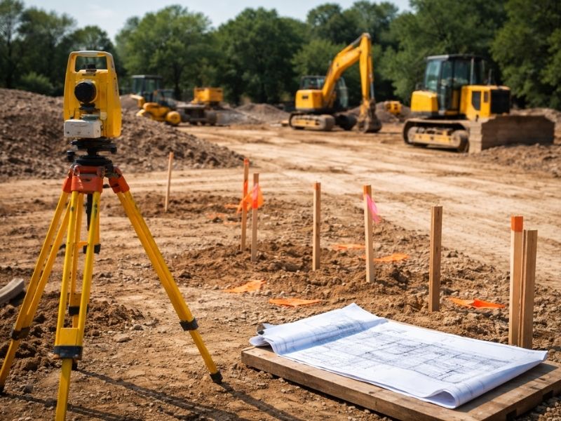
Construction survey equipment and site staking markers used to establish building locations and grading targets on a development project

Builders and developers hire architects, engineers, and contractors before a shovel hits the ground. The one professional who often gets scheduled too late, or not at all, is the construction surveyor. That’s a costly mistake. A construction surveyor is active from the day site work begins through the day the building inspector signs off, and every phase in between has a specific task that only a licensed surveyor can complete correctly.

The Construction Surveyor’s Core Job

A construction surveyor translates approved design plans into physical points on the ground. The drawings show where a building should go, what elevation the finished floor needs to be, where utilities run, and how the site drains. The surveyor takes that information and puts it on the actual land so the crew knows exactly where to dig, pour, and build.

This work requires both horizontal control (the X and Y position of every element) and vertical control (the elevation or Z position). Get either wrong, and the consequences range from a failed building inspection to a foundation that has to be demolished and repoured.

A concrete foundation poured at the wrong elevation can cost $50,000 or more to demolish and correct. The form board survey that prevents it typically costs $400 to $1,200. The math is not complicated.

Phase 1: Pre-Construction Site Work

Before any grading or clearing begins, the construction surveyor establishes the control network for the entire project. This means setting reference points and benchmarks across the site that everything else will be measured from. These control points are the anchor for every subsequent survey visit.

At this stage, the surveyor also reviews the design plans and compares them against field calculations. If there’s a discrepancy between what the plans show and what actually exists on the ground, finding it before the crew mobilizes is far cheaper than finding it mid-construction.

Rough grading staking follows. The surveyor marks cut and fill limits, drainage flow lines, and elevation targets so the grading contractor knows where to move earth and to what finished grade.

Phase 2: Construction Staking

Once the site is prepared, construction staking begins. This is the phase most people associate with a construction surveyor: placing stakes and flags on the ground to show the crew where to build.

Stakes mark:

  • Building corners and foundation lines
  • Setback limits from property lines
  • Utility corridors for water, sewer, gas, and electrical
  • Road centerlines, curb lines, and pavement edges
  • Retaining walls, grading limits, and drainage features

Each stake carries information: a description of what it represents, an offset distance if needed, and an elevation reference. The crew uses this to position every element of the project correctly.

Staking happens in phases tied to the construction schedule. Rough grading staking comes first, followed by utility layout, then building corners, then fine grading as the project progresses. The surveyor returns at each phase.

Phase 3: The Form Board Survey

Before concrete is poured for a slab foundation, the construction surveyor performs a form board survey (also called a foundation survey). This is one of the most time-sensitive tasks on any residential or commercial project.

After the contractor sets the wooden forms that will contain the concrete, the surveyor measures the top of each form board and compares it to the elevation specified in the engineering plans. If the forms are too low, the finished floor won’t meet flood zone requirements and the building may not pass inspection. If they’re too high, drainage, ramp grades, and ADA compliance become problems.

Most building departments require a form board survey before authorizing the pour. The surveyor delivers results the same day or within 24 hours. Scheduling this visit 24 to 48 hours before the planned pour is the standard recommendation. Waiting until the morning creates schedule risk that benefits no one.

Phase 4: Progress Surveys During Construction

On larger projects, the construction surveyor returns at intervals during the build to verify that work is proceeding within tolerance. This might involve checking pipe invert elevations before a trench is backfilled, verifying wall alignment as framing goes up, or confirming that a road subbase is at the correct grade before paving begins.

These mid-construction checks matter because errors that get buried are far more expensive to fix than errors caught in the open. A utility pipe installed at the wrong elevation is relatively easy to correct before the trench is filled. After backfill, finding and fixing it requires excavation, then re-excavation, plus any damage to surrounding work.

Phase 5: Coordination With the Project Team

A construction surveyor doesn’t just work in the field. They review plans, communicate with project managers, engineers, and building inspectors, and flag issues before they become site problems.

When plans change mid-project, as they frequently do, the surveyor needs current information to re-stake elements accurately. A wall that moves three feet to avoid a utility conflict needs to be re-staked with the updated drawings, not the original ones. The surveyor keeps the physical site aligned with whatever the current approved plans actually say.

On projects where the building department requires a licensed surveyor to certify certain inspections, this documentation role is also part of the job.

Why Timing Matters

The most common mistake developers make with construction surveying is treating it as an on-call service rather than a scheduled one. Survey visits need to be coordinated with the construction schedule, not inserted as afterthoughts.

A good rule: involve the surveyor before design is finalized when possible. The control data and topographic information the surveyor collects during pre-construction feeds directly into the engineer’s design. When that data is collected early and accurately, the whole project runs on better information from the start.

Surveyors who work a project from start to finish maintain consistent control data, understand site conditions as they evolve, and catch problems earlier than a surveyor brought in cold at a single phase.

Frequently Asked Questions

What does a construction surveyor do? 

A construction surveyor translates approved design plans into physical points on the ground. They establish site control, stake the locations of buildings, utilities, and grading features, verify foundation elevations before concrete is poured, check progress at critical phases, and document the final built conditions for permit closeout.

What is construction staking? 

Construction staking is the process of placing physical markers on a construction site to show crews where to build. Stakes mark building corners, setback lines, utility routes, road alignments, and grading limits. The markers carry elevation references and descriptions that guide contractors throughout the project.

What is a form board survey and when is it required? 

A form board survey verifies that the wooden forms set for a concrete foundation are positioned at the correct elevation before the pour. Most building departments require this survey before authorizing the concrete pour. If the forms are at the wrong elevation, the foundation, and potentially the entire structure, will not meet the approved plans or flood zone requirements.

How many times does a construction surveyor visit a site? 

The number of visits depends on the project size and type. A typical residential project requires visits for pre-construction control and staking, a form board survey, and a final as-built survey. Commercial projects add utility staking, progress checks, and often multiple intermediate verification visits tied to inspection milestones.

When should a construction surveyor be brought in? 

The earlier, the better. Ideally, a surveyor is involved before the design is finalized so that accurate topographic and control data informs the engineering plans. At minimum, the surveyor should be engaged before site clearing begins so that control points can be established before any earthwork disturbs the site.

Posted in land surveying | Tagged construction survey, construction surveyor

How LiDAR Mapping Helps Solve Flood Risk Problems for Property Owners

Jacksonville Land Surveying Posted on June 3, 2026 by JaxsurveyorJune 9, 2026
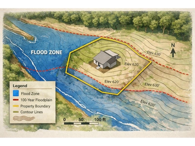
LiDAR-based flood risk map showing property boundaries, contour lines, elevation data, and nearby flood zones

Most flood problems on a property get discovered after a purchase closes or after construction starts. By then, the options are expensive and the timeline is broken. LiDAR mapping gives property owners and developers a way to see flood risk before those decisions are made, using precise elevation data that older survey tools and public maps simply can’t match.

Why Standard Maps Fall Short for Flood Risk Decisions

Most publicly available flood maps were built with terrain data that measures elevation in 20-foot intervals. In flat areas where a single foot of grade change separates dry land from a flood path, that resolution is not enough to make sound decisions.

The problem goes beyond inaccuracy. Many official flood maps are more than 10 years old. For a large portion of the country, no detailed flood data exists at all. A parcel might sit in an area with no mapped flood zone on file, yet still drain poorly, hold standing water, or funnel runoff toward a proposed building pad.

LiDAR Data captures terrain at 1-meter resolution or finer. That’s the difference between seeing a general elevation trend and seeing exactly where water will move across a specific parcel. For a developer planning roads, grading, and stormwater systems, that level of detail changes how a site gets designed from the start.

What LiDAR Mapping Captures That Other Methods Miss

LiDAR works by firing millions of laser pulses per second from a drone or aircraft. Each pulse bounces off the ground and returns to the sensor. The time it takes to return tells the system exactly how high that point sits.

After processing, the data produces what’s called a bare earth model. Vegetation, buildings, and structures are removed from the dataset. What remains is the raw terrain surface with centimeter-level vertical accuracy.

That model reveals micro-topographic features that standard surveys and coarser contour maps miss entirely: shallow depressions, subtle drainage channels, natural flow paths, and low spots between elevated areas. For flood risk analysis, those small features matter most. A six-inch depression holds standing water after a storm. A narrow low channel between two raised areas funnels runoff directly toward a building pad. LiDAR finds those conditions before they become construction problems.

How Developers Use LiDAR Data Before Breaking Ground

Pre-development site analysis is where LiDAR mapping delivers the most value. Before a site plan gets drafted or a permit application goes in, LiDAR data answers questions that affect the entire project.

Where does water go on this site after heavy rain? LiDAR-derived terrain models show drainage flow paths across a parcel. Engineering consultants use this data to model runoff, design stormwater systems, and determine where detention or retention areas need to go. Getting this right in the design phase costs far less than correcting drainage failures after a slab is poured.

Which portions of the site carry the most flood exposure? Not every acre of a large parcel carries the same risk. LiDAR elevation data lets planners identify the lowest areas and where flood inundation could reach during a significant storm. That information drives decisions about pad elevations, building placement, and which portions of a site to keep as open space.

Does this site have drainage capacity for the proposed impervious surface? Every new building, parking lot, and driveway increases runoff. LiDAR data supports the calculations that determine whether the site can handle that load or whether it will push water onto neighboring properties.

Public LiDAR Data vs. a Site-Specific Survey

Federal and state agencies maintain publicly available LiDAR datasets for portions of the country. These are useful for early screening but carry limitations that developers and property owners need to understand before relying on them.

Public LiDAR data is typically collected at the county or watershed scale. It may be several years old. It was gathered to meet broad mapping standards, not to answer specific questions about a single parcel.

A site-specific LiDAR survey commissioned for a project captures current conditions at the density and resolution needed for engineering design and permitting. The difference between using public data and ordering a fresh survey is the difference between a general picture and a certified document you can submit to a building department.

For commercial or multifamily projects, the cost of a site-specific LiDAR survey is a small fraction of the total project budget. The data informs grading plans, drainage design, and site layout decisions that affect every dollar spent in construction. Research on high-resolution LiDAR models, including studies published in peer-reviewed hydrology journals, consistently shows substantially improved flood inundation predictions compared to coarser terrain data.

When a Property Owner Needs Site-Specific LiDAR Data

Not every property needs a commissioned LiDAR survey. Public datasets may be sufficient for an initial screening. A site-specific survey is worth ordering when:

  • The parcel is large (10 acres or more) with uneven terrain or drainage complexity
  • The property sits near a creek, wetland, drainage canal, or tidal feature
  • A portion of the site appears on flood maps but the exact boundary is unclear
  • The project involves significant grading, fill, or drainage infrastructure
  • A stormwater management plan is required as part of the permitting package
  • The public LiDAR data for the area is more than five years old or unavailable

For smaller parcels with flat, simple terrain in established subdivisions, a standard topographic survey usually provides enough data for site planning.

Frequently Asked Questions

How does LiDAR mapping help with flood risk assessment? 

LiDAR creates high-resolution bare earth elevation models that show how water moves across a site. Engineers and planners use this data to identify low spots, drainage flow paths, and flood-prone areas before construction begins. This supports better grading design, stormwater system placement, and informed decisions about building pad elevations.

Is public LiDAR data accurate enough for site planning? 

Public LiDAR datasets are useful for initial screening but are often outdated and collected at lower resolution than a commissioned survey. For projects requiring engineered drainage plans or permitting documentation, a site-specific LiDAR survey provides current, certified data suited to the project.

How accurate is LiDAR compared to older elevation data? 

LiDAR captures ground elevation at resolutions of 1 meter or finer with vertical accuracy measured in centimeters. Traditional contour maps used for flood mapping measured elevation at 20-foot intervals. Peer-reviewed research has consistently shown that 1-meter LiDAR-derived terrain models produce substantially more accurate flood inundation predictions than coarser datasets.

At what project size does a LiDAR survey make sense? 

For parcels of 10 acres or more, especially those with drainage complexity or proximity to water features, a site-specific LiDAR survey typically pays for itself through better site design and fewer engineering revisions. Smaller lots with simple terrain may not require one.

How long does a LiDAR survey take to complete? 

Fieldwork on a drone LiDAR survey for a development site typically takes a few hours. Data processing and delivery of the elevation model and derived outputs usually follow within one to two weeks, depending on project scope.

Posted in land surveying | Tagged drone survey, lidar mapping

Post navigation

← Older posts
Newer posts →
Get Quote Button

Jacksonville Florida Land Surveyors

© Copyright Jacksonville Land Surveying
Jacksonville, FL
Phone: 904-712-2289

Privacy Policy | Terms of Use
Web Development and SEO by:
N2Biz.co
↑